Brace yourselves! A powerful and dangerous ice storm is brewing. This week, millions from the Midwest to the Northeast could face a travel nightmare. The FOX Forecast Center warns of sleet, freezing rain, and icy roads that could cripple entire regions.
A perfect winter storm forms
A series of brutal atmospheric river storms has been hammering the West Coast. Now, one of these storms will spark a fresh wave of winter chaos.
By Tuesday, a low-pressure system will form over the Plains. At first, it won’t have enough moisture to strengthen. But as it moves eastward, a powerful southerly jet stream will kick in. Warm, moisture-packed air will surge across the eastern U.S. This will create a sharp warm front, separating freezing northern air from record-breaking heat in the South.
Icy nightmare on the horizon
This setup spells trouble. Warm air will slide over a stubborn layer of subfreezing air near the surface. That’s the perfect recipe for freezing rain.
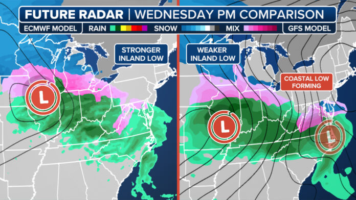
The FOX Forecast Center says computer models are still debating the storm’s exact path. Will it track east as expected? Or will a new coastal low develop along the East Coast?
Scenario 1: The worst-case ice disaster
If the first scenario unfolds, a powerful low-pressure system will dominate the Plains. A stronger jet stream will drag in warm, moist air. That means more freezing rain along the Interstate 90 corridor.
Des Moines, Chicago, Syracuse, and Burlington—beware! These cities could see dangerous ice buildup. Roads will be treacherous, and power outages are likely.
“It covers a huge area,” warns FOX Weather Meteorologist Craig Herrera. “This isn’t just a thin, narrow band. It’s widespread. That makes it even more dangerous, especially for commuters.”
Meanwhile, subfreezing air will pour into the Upper Midwest. Heavy snow could blanket areas just north of the icy zone.
“The top end of ice accumulation could be a tenth to a quarter-inch,” says Meteorologist Britta Merwin. “That’s enough to knock out power. Travel will be a mess. Stock up on supplies now.”
Scenario 2: A slightly softer blow
If a new coastal low takes over, the Midwest might catch a break. The weaker jet stream would mean less widespread ice. But parts of the Ohio Valley and Pennsylvania could still see significant icing.
Des Moines and Chicago could dodge the worst. Syracuse and Burlington might shift to an all-snow event instead. But don’t relax just yet.
Brace for a travel nightmare
If the first scenario wins, a massive stretch of I-90 will turn into an ice rink. Travel disruptions could be severe. Power outages could leave thousands in the dark.
A powerful jet stream could push freezing rain deep into New England. But heavy rain might wash away some ice before it hardens.
If the second scenario plays out, the Midwest avoids the worst. But the Northeast still won’t escape unscathed. Expect significant icing along I-90.
This storm is still a few days away. Forecasts could change. But one thing is clear: it’s time to get ready.
Download the FOX Weather app. Stay alert. Stock up on essentials. And if you’re in the storm’s path—stay safe!


