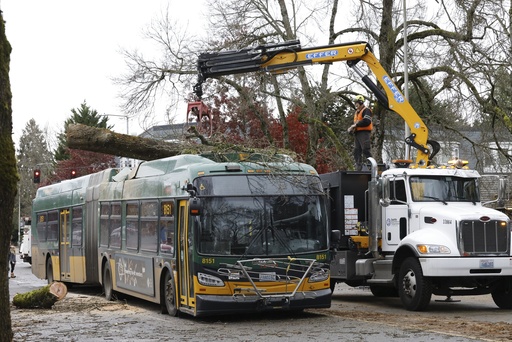
SAN FRANCISCO — A powerful storm, deemed one of the most intense to hit the West Coast in recent decades, has resulted in widespread power outages, damaging winds, and fatalities in Washington. After making its way through Oregon, the storm has reached Northern California, delivering heavy snowfall and record rainfall on Thursday.
The National Weather Service has issued a flood watch that will remain in effect until Saturday for regions located north of San Francisco. This storm is characterized as the most potent atmospheric river of the season, which refers to a significant moisture plume that forms over ocean waters and subsequently moves inland, leading to heavy precipitation.
The storm system, which made landfall on Tuesday as a phenomenon known as a “bomb cyclone” — marked by a rapid intensification — is anticipated to produce moderate to heavy rainfall until Saturday, raising concerns about flash flooding and rockslides, according to meteorological experts.
In Washington, approximately 285,000 residences and businesses were without power on Thursday due to fierce winds that uprooted trees and damaged properties. Tragically, the storm claimed two lives; a woman in Lynnwood was killed when a large tree collapsed on a homeless encampment, while another woman in Bellevue died when a tree fell onto her residence.
In response to the severe conditions, cities have set up warming centers equipped with free internet access and charging stations for electronic devices. Puget Sound Energy indicated that complete power restoration might not occur until midday Saturday in the hardest-hit regions east of Seattle. Additionally, several schools across the Seattle area were closed on Wednesday, some extending through Thursday, particularly in Enumclaw, where wind gusts reached an alarming 74 mph (119 kph).
The impact of the storm also reached Northern California, where over 20,000 customers were experiencing power outages on Thursday. Many school districts in Sonoma County announced closures due to the inclement weather.
Travel conditions have become perilous, with about 150 flights at San Francisco International Airport experiencing delays on Thursday, alongside numerous cancellations following a troublesome Wednesday for air travel. Consequently, a segment of the iconic Avenue of the Giants in Northern California was closed due to flooding, prompting warnings from the National Weather Service about slick road conditions, particularly in the Sierra Nevada region.
A winter storm watch has been declared for areas in the northern Sierra Nevada above 3,500 feet (1,100 meters), which could receive around 15 inches (38 cm) of snow over the next two days. Wind gusts in mountainous regions may exceed 75 mph (120 kph). Maggie Eshbaugh, a marketing manager at Sugar Bowl Resort northwest of Lake Tahoe, noted that about a foot (30 centimeters) of snow had accumulated by Wednesday night. She expressed enthusiasm for opening the resort, marking the earliest opening in 20 years.
An 11-mile (18-kilometer) segment of Interstate 5, connecting Ashland, Oregon to the California border, was closed on Wednesday morning due to severe winter conditions in Northern California but reopened by the evening. While Highway 6 near Oregon’s coastline sustained some damage, reports indicate minimal harm across the region as of Thursday.
Rain and snow from this storm could persist into the following week, with a second, milder wave anticipated from Saturday through Tuesday in Northern California, according to meteorologist Courtney Carpenter from the National Weather Service in Sacramento. This subsequent wave is expected to deliver lighter precipitation at lower elevations but may lead to heavier snowfall in the mountains, affecting lower areas compared to the initial wave.
Officials have cautioned about the potential for flash flooding, rockslides, and debris flows, particularly in regions where recent wildfires have disturbed the soil. Scott Rowe, a hydrologist for the Sacramento weather service, mentioned that so far, the ground has adequately absorbed moisture in Butte and Tehama counties, which were impacted by the Park Fire earlier this summer.
“It’s not merely about the volume of rain; the speed at which it falls is crucial,” Rowe added on Thursday.

