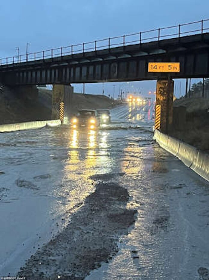
A massive storm is taking over five U.S. states. This storm, moving in from the Northwest, is causing serious flooding. It brings heavy rain, strong winds, and the risk of power outages. Flood warnings are widespread. The storm’s impact will be felt across Washington, Oregon, California, and Montana.
Flash flooding, winds and power outages
The storm will hit starting Monday. Meteorologists are warning of flash floods and downed trees. Power outages are likely. The rain will be intense. Parts of Washington and Oregon have already been drenched with up to four inches of rain. Flash flooding is already affecting the region. According to AccuWeather, rain will continue to pour. Some areas will get three to eight inches in lower regions. In mountainous areas, rainfall could reach 16 inches. Melting snow will add to the flooding risk. River flooding remains a big concern.
Storm warnings for the Northwest
The National Weather Service (NWS) has issued storm warnings. This includes gale warnings along the coasts of Washington, Oregon, and California. Gusts will be strong. Coastal areas could see winds up to 80 mph. Inland areas won’t escape either. Gusts will reach 40-60 mph. In cities like Seattle, the winds will be intense. These strong winds could cause damage to power lines and trees. The storm is expected to ease by Tuesday afternoon. But the damage will already be done.
Rain and snowmelt combine for dangerous conditions
The rain is falling on already saturated ground. Snow in the mountains is melting fast. This combination will make things worse. Flash floods could happen more frequently. Some areas could see more rain in two days than they have all month. Counties under flood warnings include Coos and Wheeler in Oregon. Malheur and Latah in Idaho are also affected. Spokane and Whitman in Washington are also at risk. The situation is dire. Hinson explained that the storm is part of an ongoing atmospheric river pattern. “It just won’t stop raining,” he said.
Atmospheric river brings intense rain
An atmospheric river is causing all this rain. It’s a narrow band of moisture in the air. It’s common on the West Coast. These storms contribute to 30-50% of annual rainfall. The rain is falling on slopes covered with weak snow. This increases the risk of avalanches. Hikers are strongly advised to stay indoors. This is a dangerous situation. The rain will continue through Tuesday. Flood risks remain high. The storm will leave destruction in its wake.
String jet brings intense winds
A “string jet” will add to the chaos. This rare weather phenomenon brings fierce winds. It looks like a bee’s stinger in satellite images. Winds could reach 100 mph along the Washington-Oregon border. These winds will cause serious damage. Downed trees are expected. Power outages will affect large areas. Areas along the western borders of Idaho and Nevada will also feel the force. By Tuesday morning, the worst of the wind will pass. But the damage will already be widespread.
Calm elsewhere as temperatures rise
While the Northwest is struggling, other parts of the country will see warmer weather. Temperatures will rise significantly this week. Highs across most of the U.S. will be 10-15 degrees above average. This feels like spring. The Southwest will see even higher temperatures. From Southern California to New Mexico, the heat will be intense. Phoenix and Los Angeles will see temperatures soar into the low 90s by midweek. This will be the first taste of summer heat for the year.
Plains and Northeast to warm up
The Plains will also experience a big change. Highs will hit the 60s and 70s on Tuesday. This is a huge difference from last week’s cold. It will feel like a sudden jump into spring. Meanwhile, further east, the mid-Atlantic states will start warming up. Temperatures in the 40s and 50s will be common. The warmth will continue into Wednesday. But the break from winter will be short-lived.
Warm weather in the Southeast
In the Southeast, cities like Charlotte and Nashville will enjoy warmer days. Highs will reach the 60s by midweek. This will feel like a welcome change. The temperatures will rise steadily through the week. It will feel much more like spring. But enjoy it while it lasts. The weather is always unpredictable this time of year.
Unpredictable weather ahead
Warm temperatures won’t stay forever. Meteorologists warn of another cold front. The warmth could be replaced by winter chills. This time of year is known for unpredictable weather. Bursts of spring-like temperatures often come with sudden cold spells. So, don’t get too comfortable just yet. The shift between seasons is here.


