BUFFALO, N.Y. — Following the bustling Black Friday shopping frenzy, parts of New York state are experiencing their first significant snowfall of the season, transforming the landscape into a winter wonderland. With the arrival of snow, forecasters have predicted a potential accumulation of 4 to 6 feet (1.2 to 1.8 meters) of snow in regions like Watertown and areas east of Lake Ontario, with these conditions anticipated to persist through Monday.
After a fall characterized by milder temperatures, residents along Lake Erie, particularly south of Buffalo, can expect between 2 to 3 feet (0.6 to 0.9 meters) of snow due to lake-effect bands notorious for producing heavy snowfall rates of 2 to 4 inches (5 to 10 centimeters) per hour. This phenomenon occurs when warm, moist air rising from the relatively warm waters interacts with the colder, dry air above, leading to intense snow showers.
“We are experiencing lake temperatures averaging 50 degrees (10 degrees Celsius), which is significantly warmer than typical for this time of year,” remarked Erie County Public Works Commissioner William Geary. He noted that the warm conditions are contributing to the heavy snowfall forecasts, reminding residents to expect more snow in the coming weeks as December approaches.
In response to the impending weather challenges, Governor Kathy Hochul declared a disaster emergency for the affected counties, facilitating the mobilization of state resources. Deteriorating conditions on Friday led to the closure of sections of Interstate 90 and a travel ban for commercial and tandem vehicles on Interstate 86 and much of state Route 219 as the snow began to accumulate.
“There has been a significant number of vehicles going off the road on Route 219 as conditions worsen,” stated Gregory Butcher, Erie County’s deputy director for preparedness and homeland security, during a briefing. He mentioned that snowmobiles and ATVs were being strategically positioned throughout the county to assist emergency responders as needed.
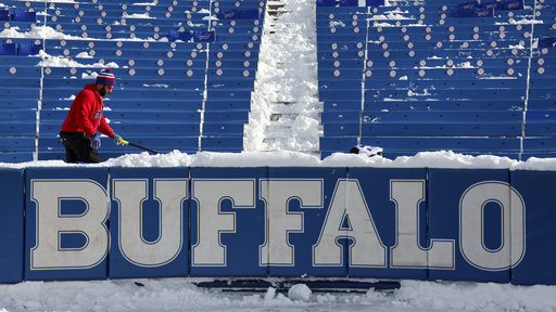
The Buffalo Bills reached out for volunteers to help clear snowfall at Highmark Stadium, anticipating over 2 feet (0.6 meters) of snow before their Sunday night match against the San Francisco 49ers. Last year’s major lake-effect storm even resulted in the NFL rescheduling the Bills’ playoff game against Pittsburgh.
“Travel will be challenging, that’s for sure,” acknowledged Erie County Executive Mark Poloncarz, while he expressed optimism that the heaviest snowfall would conclude in time for the game’s kickoff. Meanwhile, the Bills are bracing themselves to play under any weather conditions, with head coach Sean McDermott emphasizing their preparedness for the unpredictable weather coming off the lake.
The Bills currently hold a 9-2 record, their best start since 1992, and a victory this weekend would secure their fifth consecutive AFC East title. The heavy snowfall wasn’t just confined to New York; certain regions of Michigan’s Upper Peninsula were also experiencing significant lake-effect snow, with some areas reporting over a foot (0.3 meters) of accumulation by Friday afternoon.
“The setup is ideal for prolonged lake-effect snowfall due to the cool air mass and prevailing westerly winds,” explained meteorologist Lily Chapman. Forecasts from the National Weather Service in Gaylord indicated that some areas in the Upper Peninsula could collect up to 3 feet (0.9 meters) of snow by late Sunday night into Monday.
Accompanying the snowfall are strong winds, particularly around the Great Lakes, leading to reduced visibility on the roads. Joe DeLizio, another meteorologist with the National Weather Service, reported low visibility conditions but had not received information about any significant accidents as of yet, advising travelers to proceed with caution.
As snow continues to blanket both New York and Michigan, locals are urged to stay updated on the weather conditions and to travel safely during this winter storm.
