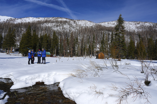
At Phillips Station, located in the Sierra Nevada mountain range, a snow depth of 24 inches (61 centimeters) was documented by Andy Reising, who oversees the Department of Water Resources’ snow surveys and water forecasting division. Currently, the water content of this snowpack stands at 91% of the typical for this time of year, while it measures only 37% of the usual for April 1, a date that generally marks the peak of the Sierra snowpack, Reising noted.
“At present, I’m feeling somewhat optimistic, but… it’s crucial that we receive a string of storms each month to sustain this momentum,” Reising stated, mentioning that the northern part of the state has benefitted from a series of storms, while the southern parts remain relatively dry.
The snowpack acts as a significant frozen reservoir, supplying nearly one-third of California’s annual water usage as it melts and flows into streams and rivers come spring. The state has developed an intricate network of canals and dams designed to collect and store this water in large reservoirs for use during dry periods throughout the rest of the year.
The figures from these snowpack measurements are of great concern in California, home to 39 million residents and responsible for producing over one-third of the nation’s vegetables and three-quarters of its fruit and nuts. The status of the snowpack is a critical factor in determining whether there will be sufficient water supplies for agriculture and urban areas during the summer months.
This recent survey marks the initiation of a series of manual measurements for the season at Phillips Station. In addition to these manual assessments, the department also utilizes electronic instruments at various locations, revealing that the snowpack across the state is currently at 108% of the average.
Many of the state’s reservoirs are reported to be filled to two-thirds or three-quarters of their total capacity, well above the historical averages at this time of year, predominantly due to two consecutive years of favorable snowpack conditions. Recently, officials conveyed to farmers and urban areas reliant on state water that they can anticipate receiving more water than originally planned, triggered by strong storms at the end of 2024. The allocation has increased to 15% of their requested water instead of the previously anticipated 5%, with the possibility of further increases if the precipitation pattern continues.
Nonetheless, state water authorities pointed out that the central and southern regions of California’s mountainous areas are not experiencing as much precipitation as their northern counterparts. Michael Anderson, the state climatologist, indicated that a high pressure system off the Pacific Coast has been steering stormy weather toward the northern areas and is expected to persist in doing so over the next couple of weeks. This could prevent those central and southern mountains from reaching historic snowpack averages.
According to Anderson, “Looking at historical patterns, while it’s not impossible, it is unlikely.” He added that they are currently monitoring the situation closely.
In contrast, this time last year, the state commenced the season with below-average snowpack and water content at roughly 25% of what is typically expected. By April, the measurements surged to 110% of the average, following an impressive snowpack to start 2023, largely due to a series of atmospheric rivers that aided California in emerging from a three-year drought.


