OMAHA, Neb. — A significant ice storm impacted travel in Iowa and eastern Nebraska this past weekend, leading to dangerous conditions on the roads and temporary closures of Interstate 80 as numerous vehicles skidded off.
Many regional events were called off as the storm began on Friday evening, causing businesses to announce late openings on Saturday. Officials strongly advised residents to remain indoors unless absolutely necessary. Fortunately, afternoon temperatures climbed enough to melt much of the ice in several areas.
“Fortunately, some warmer air is arriving, making this only a temporary issue,” noted Dave Cousins, a meteorologist from the National Weather Service’s Davenport, Iowa office.
Tragically, at least one fatality was reported from a collision attributed to icy road conditions in eastern Nebraska. According to the Washington County Sheriff’s office, a 57-year-old woman passed away when her pickup truck lost traction on Highway 30 near Arlington and collided with an oncoming vehicle. The driver of the other truck only suffered minor injuries.
In another part of the country, a storm brought wind gusts reaching 60 mph (96 kph) to San Francisco, resulting in the issuance of the first tornado warning for the area. The warning affected around 1 million residents and was issued at 5:51 a.m., lifted just 20 minutes later due to the storm’s rapid movement.
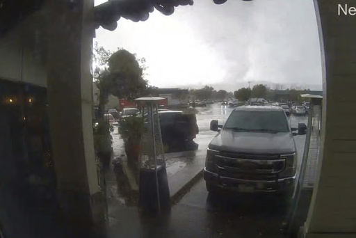
Later on Saturday, a tornado was confirmed to have touched down near a shopping center in Scotts Valley, approximately 70 miles (110 kilometers) south of San Francisco. The National Weather Service reported that this tornado caused vehicles to overturn and resulted in uprooted trees and downed utility poles.
“Video, photos, eyewitness reports, and radar data indicate that a tornado indeed touched down at 1:40 PM,” the service stated, and a team will assess the situation to determine a rating.
Social media pictures showed at least three cars flipped over, their windshields shattered, with debris scattered across the area, including fallen trees and power lines. The Scotts Valley Police Department reported several individuals sustained injuries and were taken to local hospitals.
The police department highlighted that the tornado inflicted considerable damage, particularly in the shopping district near Mt. Hermon Drive, and requested that people steer clear of the impacted area. Among the injured was a battalion chief from the California Department of Forestry and Fire Protection, according to local news.
In San Francisco, fallen trees damaged cars, roads, and rooftops. The city had not experienced a tornado since 2005, per the National Weather Service’s records. Officials were in the process of evaluating the damage to confirm the nature of the event.
“This was the first-ever tornado warning for San Francisco, which suggests there may not have been a definitive signature on radar back in 2005,” remarked Roger Gass, a meteorologist with the Weather Service in Monterey, California.
The fast-paced storm led to alerts urging residents to seek shelter; however, basements are uncommon in San Francisco. “The most critical advice we give is to place as many walls as possible between yourself and the outside,” stated Meteorologist Dalton Behringer.
In upstate New York, residents were busy clearing significant snow amounts, with over 33 inches (84 centimeters) reported in areas like Orchard Park, familiar with lake-effect snowfall this time of year.
Furthermore, Nevada was bracing for up to 3 feet (91 centimeters) of snow at higher elevations in the Sierra Nevada mountains. Lake Tahoe ski resorts recorded over a foot (30 cm) of fresh snow, with wind gusts of 112 mph (181 kph) recorded at Mammoth Mountain, located south of Yosemite National Park.
A winter storm warning was expected to conclude at 10 p.m. Saturday, but an avalanche warning would remain in effect overnight for elevations exceeding 8,000 feet (approximately 2,400 meters) around Lake Tahoe.
Interstate 80 experienced closures for about an 80-mile (130-kilometer) stretch from Applegate, California, to the Nevada border near Reno, where rain was reported, and a winter weather advisory was active through the afternoon. The California Highway Patrol reopened the highway for passenger vehicles equipped with chains, four-wheel drive, and snow tires, while it remained closed to larger semitrailer trucks.
In western Washington, reports indicated that tens of thousands of residents lost power amid a system that brought both rain and strong winds.


