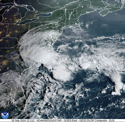
Tropical storm conditions are projected along a stretch of the U.S. Southeast seacoast as the system, with gusty winds, heavy rain, and potential flooding, shows signs of strengthening. The U.S. National Hurricane Center indicated that the storm system would likely reach the South Carolina coast on Monday afternoon before moving inland across the Carolinas from Monday night through Wednesday. Strong winds were approaching the coast on Monday morning and were anticipated to spread inland.
A tropical storm warning was put in place from Edisto Beach, South Carolina, northward to Ocracoke Inlet, near the southernmost part of North Carolina’s Outer Banks. The low-pressure system was positioned on Monday morning about 100 miles east of Charleston, South Carolina, and about 85 miles south of Cape Fear, North Carolina. It had maximum sustained winds of 50 mph and was moving northwest at 3 mph according to forecasters.
While the system still had the potential to develop into a tropical or subtropical storm, forecasters mentioned that chances may have started to decrease due to a decrease in organization. Despite this, the National Oceanic and Atmospheric Administration’s updated hurricane outlook for the highly active Atlantic hurricane season remained unchanged last month, attributing it to near-record sea surface temperatures and the possibility of La Nina. Emergency management officials have stressed the importance of staying prepared.
Although maximum winds were predicted to lessen as the low approached the coast, tropical-storm-force winds were still expected within the warning areas. Forecasters suggested that the system would likely dissipate over the Carolinas by late Wednesday. The storm was forecasted to bring 4 to 8 inches of rain to northeast South Carolina into southeast North Carolina and up to 10 inches in isolated spots. In North Carolina, smaller amounts were expected through Tuesday.
In Virginia, 1 to 3 inches, with locally higher amounts, of rainfall was expected from Monday night through Wednesday. The hurricane center warned that the rainfall could result in isolated and scattered flash and urban flooding, as well as minor river flooding. The Southeast coast was also expected to experience rough surf in the upcoming days. Elsewhere in the Atlantic, Tropical Storm Gordon weakened to a depression as it moved through open ocean waters. Gordon could either dissipate in the coming days or regain strength as a tropical storm as stated by forecasters.
