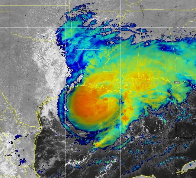
Louisiana residents are preparing for Hurricane Francine’s landfall as the storm intensifies into a life-threatening hurricane, sweeping across the Gulf Coast with the potential to bring up to a foot of rain, damaging winds, and a storm surge as high as 10 feet in some areas.
As of 4 p.m. ET, Francine’s hurricane-force winds were nearing the southern Louisiana coast, with sustained winds reaching 90 mph. The National Hurricane Center issued urgent warnings for residents to stay indoors, away from windows, and to have multiple ways to receive alerts and updates.
Current Situation and Impact
The eye of Francine was located about 60 miles south-southwest of Morgan City, Louisiana, and the storm is moving northeast at 17 mph. Hurricane-force winds extend up to 40 miles from the center, with tropical storm-force winds reaching 115 miles. The National Weather Service in New Orleans warned of deteriorating conditions along the coast, urging residents to complete preparations and shelter in place through the storm’s impact, which could last into Thursday morning.
Reports of power outages are already coming in, with over 3,000 outages along the Louisiana coast. Governor Jeff Landry announced the mobilization of the National Guard, which has 400 high-water vehicles, 87 boats, and 50 helicopters ready for rescue and recovery operations. President Joe Biden approved Louisiana’s emergency declaration late Tuesday, enabling federal assistance for response and disaster relief efforts.
Business Disruptions and Evacuations
Morgan City, one of the projected landfall areas, has imposed a curfew from 11 a.m. Wednesday to 6 a.m. Thursday, with residents urged to shelter in place. Despite the impending storm, some locals like Trenton Ho, a cashier at a local store, remain unfazed. “I’m not the least bit concerned about this storm,” Ho said. “When you have lived here your whole life, you are used to this stuff.”
Mandatory and voluntary evacuations have been ordered in several Louisiana parishes, including Terrebonne and Lafourche. Shelters have been opened, and residents in FEMA-provided housing or state-issued RV campers in Lafourche Parish are under mandatory evacuation.
Threats Beyond Louisiana
As Francine moves inland, it poses a risk to other southeastern states, including Mississippi, Alabama, and Florida, with potential tornadoes and severe thunderstorms. The National Hurricane Center forecasts rainfall totals of 4 to 8 inches, with local amounts up to 12 inches, leading to the possibility of significant flash and urban flooding.
AccuWeather warns that tornadoes are likely on Wednesday in southeastern Louisiana, southern Mississippi, and southern Alabama, with the risk extending to a larger area on Thursday. The introduction of dry air into Francine’s circulation could increase the number and intensity of severe thunderstorms and tornadoes.
Economic and Environmental Impact
Francine’s approach has also prompted oil and gas companies in the Gulf of Mexico to halt production, with 24% of oil output and 26% of natural gas production shut down. Exxon Mobil Corp’s refinery in Baton Rouge is reducing operations, potentially cutting production to as low as 20% of its capacity as the storm nears.
Looking Ahead
Hurricane Francine is the third hurricane to make landfall on the Gulf Coast this year and the fourth hurricane of the 2024 Atlantic season. With hurricane season reaching its peak, forecasters are monitoring four additional disturbances across the Atlantic, though none pose an immediate threat to land at this time.
Governor Landry continues to emphasize the importance of preparedness, urging residents to follow local officials’ instructions and stay updated through local news sources. As the storm approaches, Louisiana and its neighboring states brace for potentially life-threatening conditions and significant disruptions.
