Key Point Summary – Tropical Storm Dexter to Form
- NHC expects Tropical Storm Dexter to form by Monday
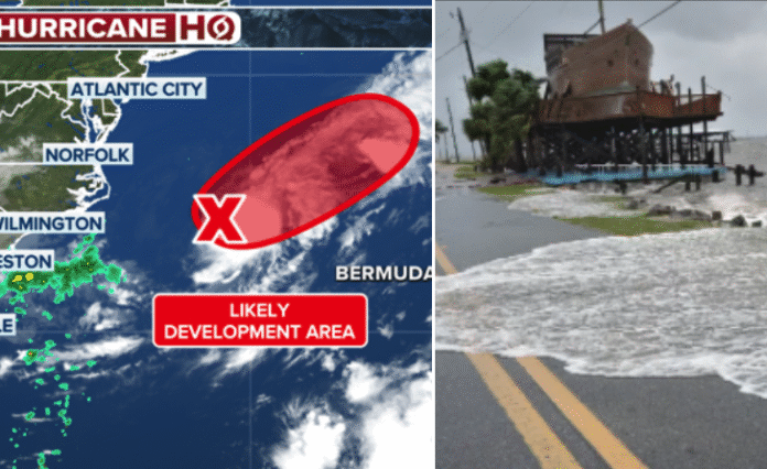
- Invest 95L located east of North Carolina with gale-force winds
- System has 70%+ chance of development within 48 hours
- Already deadly flooding reported in Alabama due to heavy rain
- Southeast to be soaked all week with 4+ inches possible
- Multiple systems monitored, including one near Africa
- Public bracing for more flash floods and storm chaos
A storm is gaining power off the U.S. East Coast—and it’s coming in hot. Forecasters now say Tropical Storm Dexter is likely to form by Monday as Invest 95L churns just a few hundred miles east of North Carolina.
This area of disturbed weather is no longer just a curiosity. It’s a ticking time bomb with gale-force winds already swirling through the Atlantic.
Invest 95L Sparks Alarm Along Coastline
The National Hurricane Center is keeping a close eye on Invest 95L. Though still technically part of a frontal system, the disturbance has rapidly organized. Wind speeds have hit tropical-storm levels, and all signs point to one outcome: Tropical Storm Dexter is on the way.
Satellite data confirms it’s no ordinary summer squall. “Environmental conditions are conducive for this system to acquire additional tropical characteristics,” the NHC stated.
Translation? Dexter is coming.
Flooding Already Turns Deadly in the South
Before Dexter even earns his name, the Southeast is already drowning.
In Cleburne County, Alabama, tragedy struck Sunday morning. A car was swept away in flash floodwaters. One person died. Another was found clinging to a tree.
Heavy rains have hammered Georgia, South Carolina, and Alabama. With the region soaked from days of thunderstorms, the worst could still be ahead.
Tropical Storm Dexter to Form: What Happens Next
Rainfall forecasts show parts of the Southeast may get dumped with up to 4 inches of rain by midweek. And that’s before Dexter gets fully tropical.
While the system is expected to stay offshore for now, its outer bands could lash the Carolinas and Georgia with torrential rain and strong gusts.
Add to that a slow-moving cold front acting like a sponge—and the entire region becomes a flood trap.
Cold Front + Dexter = Flooding Disaster?
A powerful cold front has stalled over the Deep South. It’s combining forces with moisture from the Gulf of Mexico and now from Invest 95L. The result: round after round of storms.
The Lowcountry of South Carolina, southern Georgia, and most of Alabama are in the bullseye.
And it’s not just Invest 95L. Two more systems are in play—one off the Southeast coast and another just rolling off Africa.
Public Reaction: Bracing for the Worst
Across social media, panic is rising. #DexterStorm trended overnight as residents from Wilmington to Savannah posted images of flooded roads and eerie skies.
“I’ve lived here 20 years,” wrote one Savannah local. “Never seen anything ramp up like this. It’s July and feels like October hurricanes.”
Emergency management offices are preparing flood response teams. Shelters are opening in low-lying areas. Sandbags are flying off the shelves.
But many feel caught off guard—again.
All Eyes on Monday
According to the NHC, Invest 95L has a high chance—over 70%—of becoming a named storm in the next 48 hours. That puts Monday squarely in the danger zone for Dexter’s debut.
Once named, it would become the Atlantic’s next tropical storm, the fourth of the 2025 season.
That means tropical storm warnings could go up fast, even if the system stays offshore. Swells, rip currents, and flooding rains won’t care if Dexter hits land directly or dances nearby.
Could Dexter Strengthen Into a Hurricane?
It’s too soon to tell—but not impossible.
Models currently suggest the system will stay just shy of hurricane status. But warm waters, low wind shear, and favorable atmospheric conditions could change that fast.
It wouldn’t be the first time a storm was underestimated.
Forecast: Wet, Wild, and Worsening
Through Thursday, the Southeast will stay under siege from slow-moving storms, tropical moisture, and daily flood threats.
Forecasters say the upper-level disturbance pushing in from the east will stall, setting up the worst-case scenario for flash flooding and training thunderstorms.
That means rain falling over the same spots for hours.
The Big Picture: A Troubled Atlantic
Tropical Storm Dexter may be the star of the moment, but he’s not alone. A system off Africa is being monitored for development as it pushes westward. Another low is lingering just offshore of the Southeast.
It’s August. The Atlantic is waking up.
And for coastal residents, the message is clear: prepare now. Don’t wait for the name to be official.
Because by the time Dexter is named, it may already be too late.


