Key Point Summary – Erin East Coast
- Tropical Storm Erin expected to hit hurricane strength in 36–48 hours
- Winds could peak at 98 mph with gusts up to 121 mph
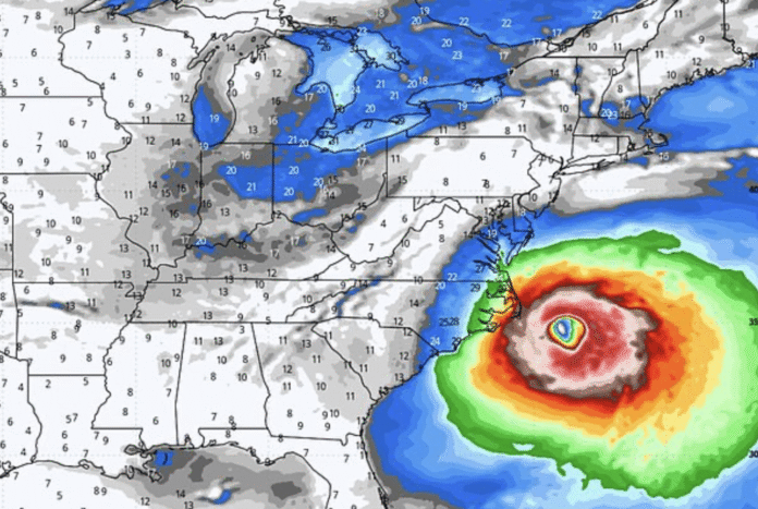
- ECMWF model shows a possible close pass to Cape Hatteras, NC
- Some forecasts keep Erin curving out to sea by August 21
- Residents along East Coast urged to prepare now
- Destructive floods in Cabo Verde Islands have already killed seven
- Possible strong winds, rain, and coastal flooding if track shifts west
Meteorologists are warning that Tropical Storm Erin could intensify into a major hurricane as it moves west across the Atlantic. For the Erin East Coast scenario, models show both relief and alarm — while many tracks curve it safely out to sea, a few keep it dangerously close to US shores.
The National Hurricane Center expects Erin to hit sustained winds of 80 mph in two days, with gusts nearing 98 mph. Seas could swell to 20 feet, making conditions hazardous for ships and mariners.
Expert Raises Alarm Over Erin East Coast Threat
Meteorologist Noah Bergen has injected new urgency into the forecast. His eight-day projection, based on ECMWF data, shows hurricane-force gusts hitting Cape Hatteras. He warns that “writing off” US impacts is risky, as the exact recurve point is still unknown.
The ECMWF, respected for its track record, uses cutting-edge modeling that blends ocean temperatures, pressure patterns, and satellite imagery. It has accurately forecast hurricane paths up to two weeks out, making its southward-leaning plot especially concerning.
Conflicting Models Add to Uncertainty
Other models still keep Erin offshore, swinging north before landfall. AccuWeather’s forecast follows that trend, showing the storm curving away from land next week. But WFLA chief meteorologist Jeff Berardelli warns the Euro and Euro AI models are “too close for comfort,” tracking Erin further south at first and delaying its turn northward.
This slight delay could spell trouble for the Outer Banks. Berardelli stresses that while the inland push isn’t the most likely outcome, the Erin East Coast path cannot be ruled out, and residents should be prepared.
Erin’s Deadly History This Week
Even before approaching the Americas, Erin has shown its deadly potential. Torrential rains unleashed catastrophic flooding in the Cabo Verde Islands on Monday, killing seven people. The tragedy underscores the storm’s power, even at its earlier stages.
Possible Path Between Bermuda and Outer Banks
Alex DaSilva, AccuWeather’s lead hurricane expert, predicts the most probable track lies between Bermuda and the Outer Banks. However, he warns that the recent southward trend in forecasts slightly increases the risk of US landfall.
Even without a direct hit, Erin’s vast size will generate dangerous surf and rip currents for much of the Atlantic coast. Swells are expected to reach North Carolina, Long Island, and southern New England early next week.
How Weather Patterns Could Shift Erin’s Course
Meteorologists are watching the Bermuda High closely. If it nudges westward while a cold front dips into the Eastern US, Erin could be steered farther toward land. That scenario would increase the risk of damaging winds, torrential rain, and flooding in major coastal areas.
“Interests along the East Coast of the US, the Bahamas, and Bermuda should monitor Erin,” DaSilva urged. “A track shift could bring direct impacts to these areas.”
Coastal Residents Watching Closely
Communities from Cape Hatteras to Cape Cod are on alert. Social media is alive with storm prep tips, grocery haul photos, and debates over whether to evacuate. Bergen’s close-pass map has already gone viral, stoking memories of hurricanes that veered landward at the last minute.
Right now, Erin sits about 990 miles east of the northern Leeward Islands, moving at 17 mph. Whether it stays offshore or roars toward land, the next two days will be decisive. The Erin East Coast scenario may still be a “what if,” but forecasters warn it’s one that could turn real fast.


