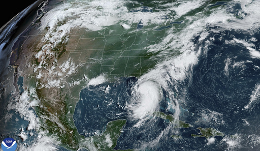
Tropical Storm Debby intensified quickly on Sunday and was forecasted to transform into a hurricane as it made its way through the Gulf of Mexico towards Florida, posing a significant risk of severe floods along the southeast Atlantic coast later in the week. The National Hurricane Center in Miami predicted that the storm would likely reach Category 1 hurricane status before hitting the Big Bend area of Florida on Monday.
Following its landfall, Debby is anticipated to move eastward across northern Florida, stalling over coastal areas of Georgia and South Carolina, potentially resulting in a high amount of rainfall and the possibility of catastrophic flooding from early Tuesday through Friday. Low-lying regions near the coast, such as Savannah in Georgia, Hilton Head, and Charleston in South Carolina, are expected to be particularly affected by flooding, as warned by meteorologist Dwight Koehn from the National Weather Service in Charleston.
By Sunday 11 a.m., Debby was situated about 130 miles west-southwest of Tampa, Florida, with maximum sustained winds reaching 65 mph and moving at 13 mph north-northwest. Florida Governor Ron DeSantis cautioned residents of the impending hurricane impact, emphasizing the likelihood of extensive rainfall, saturation, floods, and power outages. Flood control measures were being implemented at utility stations to reduce the risk of power disruptions due to flooding.
Debby marks the fourth named storm of the 2024 Atlantic hurricane season, following Tropical Storm Alberto, Hurricane Beryl, and Tropical Storm Chris. The forecast predicted Debby’s intensification as it veered off the southwest coast of Florida, benefiting from the warm waters in that area. Hurricane warnings were issued for parts of the Big Bend and the Florida Panhandle, while tropical storm warnings covered Florida’s West Coast, the southern Florida Keys, and Dry Tortugas, with a tropical storm watch extending further west into the Panhandle.
The system was expected to generate 6 to 12 inches of rain, possibly up to 18 inches in isolated areas, resulting in flash floods and urban flooding. Forecasters also warned of moderate river flooding along Florida’s West Coast due to the storm surge, with areas like Tampa Bay facing 2 to 4 feet of surge. Plans for evacuation and flood preparations were put into action, with mandatory and voluntary evacuations issued in various coastal areas, emphasizing the seriousness of the situation.


